| Home > All By Location regional map > Pittsburgh West > East Street Bridge | |||
|
|
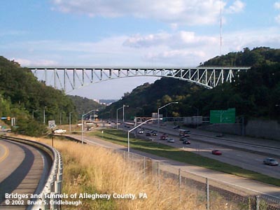
View south from a realigned East Street More detail photos OFFICIAL NAME: E. H. Swindell Bridge OTHER DESIGNATION: East Street Bridge Essen Street Bridge LOCATION: Pittsburgh USGS 7.5" Topo Quad - UTM Coordinates: Pittsburgh West - Zone 17; 0584 4480 CARRIES: Essen St; North Charles St BETWEEN: -- North Charles St near Perrysville Av (Hazelton St) -- Essen St (Penfort St; Sunset Av; Lamar St) CROSSES: -- Interstate 279 ["Parkway North," East Street Valley Expressway], three lanes northbound, two reversing lanes for High Occupancy Vehicles and Busway, three lanes southbound; East St TYPE OF CONSTRUCTION / DESIGN: spandrel-braced deck cantilever arch; main span and counter spans rest on concrete piers; side span at Charles St: parallel chord deck pratt truss on steel bent LENGTH OF MAIN SPAN: 548 ft est TOTAL LENGTH (including longest elevated ramp): 1,097 ft (west to east: 165 ft est, 192 ft est, 548 ft est, 192 ft est) HEIGHT OF DECK: 225 ft est (before construction of I-279) 170 ft est at center of main span YEAR ERECTED / ENGINEER: 1930, City of Pittsburgh Opened September 15, 1930 ADDITIONAL INFO: Though the bridge was officially named for E. H. Swindell, and though it connects North Charles and Essen streets, nearly everyone calls the structure the "East Street Bridge." E. H. Swindell, a prominent local businessman, died in October, 1928, as the bridge was being constructed. Although a direct account of the naming has not been found, it's presumed that he was the bridge's namesake. William Swindell and Brothers, a firm which built open hearth steel furnaces, was founded in 1860; the company is now Swindell-Dressler. William's son, E.H. Swindell was born in Allegheny City, now Pittsburgh's North Side. He ascended to a management position with the company in 1902. He was president of Dressler Tunnel Kilns, Newcastle Refractories and Salt Lake Lumber Co. He was also noted as a member of the board of the American Iron and Steel Institute. The Pittsburgh Sun newspaper proudly reported the opening of the Bloomfield Bridge in 1914. The article also mentioned that plans were in the works for a similar bridge to rise soon over the East Street Valley. While the Bloomfield span was constructed in about one year, the project to link Perry Hilltop and Mount Pleasant was over twenty years in the making. The hilltop neighborhood on the western side of the East Street Valley grew up along the Perrysville Plank Road, later Perrysville Avenue. The road is an extension of Federal Street, which was once the Venango Path and later the main north-south street of the former Allegheny City (Pittsburgh's North Side after 1907). Residences on the hilltop reflect the gradual development from the days of the plank road in the mid-1800s and the popularity of the streetcar through the 1930s. As the lots along Perrysville Avenue filled with homes of the latter date, in 1931 the city annexed a less-developed part of Reserve Township on the eastern side of the East Street Valley. In anticipation of the addition and to allow better connection with the established North Side neighborhoods, the bridge to link North Charles and Essen streets was built. The 1925 Hopkins map shows Essen St to be a minor street of just over one block in length; barely a half dozen buildings are shown in the plan of lots. Though the new bridge would allow better access for Spring Hill residents, the largest use came after the construction of the Northview Heights housing project, 999-unit grouping of high-rise and townhouse residences opened in 1962. Yet, telling the history of the bridge can not ignore the changing landscape in the valley below. It could just as well have been called the Butcher's Run Bridge. Now buried under Heinz parking lots and highways, a lesser-known Saw Mill Run emptied into the Allegheny River in the eastern wards of the former Allegheny City, now Pittsburgh's North Side. An alley bearing the Saw Mill name runs near the northern end of the Sixteenth Street Bridge. An 1872 map shows the stream; an 1890 map indicates it had been covered over. Near the present-day intersection of East St and Spring Garden Rd, the stream forks into two deep valleys: to the east, Spring Garden Run cuts Spring Garden Hill from Troy Hill; to the west, Butcher's Run extends nearly due north toward Ross Township. The 1872 map shows a toll house for the Butcher's Run Plank Road near intersection of East St with Venture St. Beginning around 1830, the lowlands and plains along the Allegheny River extending eastward to Herr's Island and Troy Hill as well through the bottom of the two-horned northern valley were dominated by livestock and related industries. Though Herr's Island is most well known for its stockyards, the surrounding area was filled with butchers, tanners, wool pullers and drovers who founded stockyards, tanneries, meatpacking plants, glue factories and soap works. One of the canneries which relocated downriver from Sharpsburg, was the H.J. Heinz Company. When Heinz moved to take over property from the last remaining company from this early time, David Rotenstein researched the history of the Pittsburgh Wool Company and the related industries which have since vanished. Historic American Engineering Record document Neighborhoods grew up around the factories and into the valleys. Over time, the less-santitary name "Butcher's Run" faded. The East Street Valley became more well known as a transportation gateway with the developing suburbs of the North Hills. After World War Two, the growing sprawl along McKnight Road in Ross Twp increased the traffic flowing through the valley -- with a direct connection being completed when East St and McKnight Rd were joined in 1946. In the following thirty years, East Street, though widened enough to include trolley tracks and two lanes of traffic, was overloaded. And in Pittsburgh, where all highways radiate from the central city, a large percentage of North Hills traffic was funneled through the East Street Valley whether intended for East, South or West. Elsewhere, the building of Interstate Highways added to the pressure to use the natural gateway provided by the former Butcher's Run for a similar highway. For thirty years the battles raged. But ultimately, 2,700 families were displaced. Most all of the buildings and remants of the once-densely packed neighborhood were erased. In the uncertain times awaiting the inevitiable construction of the new highway, the remaining buildings were left to decay. One of the few survivors is the 1926 St. Boniface Roman Catholic Church, a mix of Romanesque and Byzantine styles, which stands at East and Royal streets. PennDOT bought the church buildings in 1971 and allowed the parishoners to continue use until the land was needed for the new highway. In the meantime, the other buildings in the valley were cleared away. In 1977, the diocese announced the parish would be closed and merged with another nearby. Grassroots efforts resulted in the buildings being added to the Federal Register of Historic Places. In 1981, church officials decided not to close the parish and PennDOT revised the highway design to avoid the buildings. Highway construction began in 1985 and was completed by 1989; the floor of the East Street Valley was filled with the eight-lane Interstate 279 and a rerouted two-lane East St. The events have become an often-cited symbol in the contentious interaction found in planning recent highway right-of-ways and other uses of eminent domain. === The "Gateway Arch of the North Hills" is most famous simply for being for so visible -- and only from a moving vehicle. The structure itself seems a matter-of-fact piece of engineering with little architectural embelishment. Stumps of decorative lampposts, patterned railing inserts and curved, concrete portal walls hint that there may have been some greater level of detail in 1930. But anything else of style was erased in the 1980s when the deck was refurbished, Jersey barriers added along the sidewalks and chainlink fences installed. Walking along the sidewalk gives more clues to the hidden complexity of the structure. The expansion joints at various points in the deck are each different. Above the main pier near Essen St is a massive toothed joint which would present a challenge for bicycle tires. Above the steel bent near Charles St there is only a minor joint which seems to be only to prevent pavement cracking. At the Charles St abutment a rubber diaphragm covers a joint of about one foot. All of this implies the type of bearings which support the structure -- how they are arranged as a combination of fixed and sliding bearings which compensate for the lengthening and shortening of the spans in different temperatures. Seen from below, the truss members are clearly joined by hinges and pins at most locations -- indicating that the bridge was made to move. The bridge shares details with the Schenley and Panther Hollow bridges which give evidence of its City of Pittsburgh ownership: the 1930 railing pattern and the 1980s chain link fencing. The city website shows a photo labeled as the "Swindell Street Bridge" showing the structure painted in a bright rust red. Although the picture has a 2000 copyright date, the East Street Bridge is, in fact, blue...and has been for some time. FIELD CHECKED: 20-Aug-2002 INFO SOURCES: David Rotenstein, HAER; Pittsburgh Post-Gazette; 1872, 1890 and 1925 Hopkins maps; Carnegie Library of Pittsburgh, PA Department; field check Submit info or inquiry - share some facts or ask a question. Introduction -- Nearby Structures Page created: Last modified: 21-Aug-2002 |
View Larger Map 
| |
| copyright: © Bruce S. Cridlebaugh 1999-2008 All Rights Reserved | |||