| Home > All By Location regional map > Pittsburgh West > Parkway East over Mon Wharf | |||
|
|
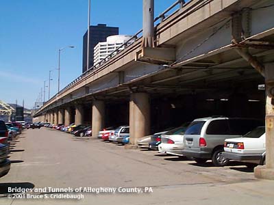
View west on Mon Parking Wharf 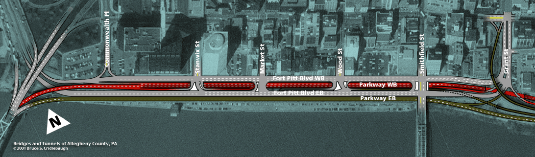
Aerial photo map More detail photos OFFICIAL NAME: Penn Lincoln Parkway East eastbound lanes Parkway East #19 OTHER DESIGNATION: Parkway Central LOCATION: Pittsburgh USGS 7.5" Topo Quad - UTM Coordinates: Pittsburgh West - Zone 17; 0584 4476 CARRIES: Penn Lincoln Parkway East [I-376; US22; US30] eastbound lanes above Monongahela Parking Wharf; 2 lanes BETWEEN: -- Fort Pitt Bridge ramps -- Grant St Interchange 3 CROSSES: -- Monongahela Wharf TYPE OF CONSTRUCTION / DESIGN: steel girder on reinforced concrete columns and bents LENGTH OF MAIN SPAN: TOTAL LENGTH (including longest elevated ramp): 1,511 ft HEIGHT OF DECK: YEAR ERECTED / ENGINEER: 1956, PA Dept of Highways ADDITIONAL INFO: The sloping embankment of the Monongahela Wharf was cut away during the 1940 reconstruction of Water St to create Fort Pitt Blvd. The boulevard was built as three street-level lanes, three river-level lanes and three more elevated lanes. A strip of land was left open between the boulevard and the river's edge. The space was filled in 1956 by the eastbound lanes of the Parkway East. The Fort Pitt Bridge ramps are carried on hammerhead piers faced with stone. As the lanes descend to the level of Fort Pitt Blvd, the two-column concrete bents support the roadway. The concrete bents and short girder spans provide a comparison of the changes in design and technology in the 16 years. The bents and columns of the new elevated lanes were designed to align with the existing supports. In the parking area of the Monongahela Wharf, five vehicles are parked side-by-side beneath each of nearly three dozen spans. Docking rings which were built into some of the columns of Fort Pitt Blvd were also added to the columns supporting the Parkway. The newer spans are simpler in most every way. Whereas the Fort Pitt Blvd girders were riveted, haunched and included suspended spans, the 1956 Parkway spans are welded girders with straight flanges mounted as simple spans. The bearings on which the girders rest are simpler than the 1940 designs. The original railings along the Parkway were aluminum tubes; in most locations they've been replaced by Jersey barriers. Until the late 1980s, there was a slip ramp from the eastbound Fort Pitt Blvd directly into the left eastbound lane of the Parkway near Wood St. It was as simple as a curb cut angling from one lane to the other. With the slow traffic timidly entering into the fast lane of the highway, it was a hazardous configuration. The cut has been closed and traffic now enters via a long ramp which descends from Wood St to merge with the Grant St entrance ramp. Fort Pitt Blvd is notorious for its deteriorating condition. But even the Parkway lanes have had wooden planks installed on the lower flanges of many girders to protect the parked cars from falling chunks. There are stencil numbers painted on several of the girders which indicate a major rehab project was conducted in 1969. More info on Fort Pitt Blvd. FIELD CHECKED: 26-March-2001 INFO SOURCES: Submit info or inquiry - share some facts or ask a question. Introduction -- Nearby Structures Page created: Last modified: 16-April-2001 |
View Larger Map 
| |
| copyright: © Bruce S. Cridlebaugh 1999-2008 All Rights Reserved | |||