| Home > All By Location regional map > Pittsburgh West > Liberty Tunnels | ||||||||||||||
|
|
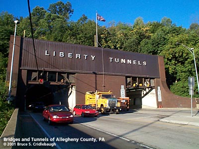
Southern portal at Saw Mill Run Blvd More detail photos OFFICIAL NAME: Liberty Tunnels OTHER DESIGNATION: Liberty Tubes LOCATION: Pittsburgh USGS 7.5" Topo Quad - UTM Coordinates: Pittsburgh East - Zone 17; 0584 4474 CARRIES: SR3096; motor vehicles, 2 lanes each tube BETWEEN: -- Liberty Bridge [SR3096]; P. J. McArdle Roadway (Mt. Washington Roadway) -- Saw Mill Run Blvd [PA51]; West Liberty Blvd [SR3096] UNDER: Mount Washington TYPE OF CONSTRUCTION / DESIGN: twin tunnels; vertical wall horseshoe profile, concrete lining, bored through rock 11 cross passages TOTAL LENGTH: 5,889 ft OTHER DIMENSIONS: 14ft 6 in posted vertical clearance Two tubes, 59 feet apart on center Pittsburgh portal, 132 ft above river level Floor slopes upward 0.329 percent grade to Saw Mill Run portal 20 feet higher Each tunnel 28.6 feet wide; originally had 21 ft roadway with 4 ft sidewalk 20.75 ft high to arch YEAR OPENED / ENGINEER: 1924, County of Allegheny Rehabilitated 2014, including restoration of original concrete portals PennDOT, current owner ADDITIONAL INFO: The growth of Pittsburgh's earliest suburbs generally followed the Pennsylvania Railroad across the relatively level areas to the city's east: Shadyside, East Liberty, Wilkinsburg. Bridges over the rivers helped feed the towns in the North Hills and the near South Side. But Mount Washington posed a difficult wall to traverse and development in the South Hills was slow. In 1871 the narrow gauge Pittsburgh & Castle Shannon Railroad began as a coal road [Pittsburgh Coal Co.]. Soon the line began to carry passengers in converted boxcars and later in coaches. The line included a tunnel which entered Mt Washington just above South Hills Junction and passed 1,741 feet to a incline station at Nimick St [now Neff St near the intersection of William St and Bailey Av]. In 1880 the tunnel was closed to passenger traffic which began to use a second incline on the back side of Mt. Washington, from South Hills Junction along Haberman Av to Bailey Av, with a short transfer to the front side incline. In 1904 William Flinn, contractor and politician, and his associates built a streetcar tunnel through the base of Mount Washington -- from Carson and Smithfield streets to South Hills Junction on Warrington Av. This tunnel connected to the P&CS line and would eventually become the Overbrook trolley line through Castle Shannon and points south. It was rebuilt as Phase Two of the PAT light rail system in 2001. Over the years the tunnel was rebuilt and updated several times to be used for the Pittsburgh Railways streetcars, Port Authority busses and the "T" light rail line which becomes Pittsburgh's downtown subway. But it was the age of the automobile which would lead to the construction of the Liberty Tunnels and the acceleration of development in the South Hills. Pittsburgh business interests were accused of favoring the eastern suburbs. The residents of the South Hills worked hard to persuade the county commissioners to realize the benefits of increased land values. In 1909 the county said it supported the idea but would not give a definite promise of when construction might start. The first proposal was the Shingiss-Haberman plan or "high" tunnel. The southern portal would have been at Haberman Av and Warrington Av [then Washington Rd] near South Hills Junction. The northern portal would have been on Mt. Washington above Arlington Av [then Brownsville Av] and East Carson St. The road would be carried on a double deck bridge over the Monongahela River to Shingiss St on the Bluff near Duquesne University. This placed the tunnel 80 feet higher at the north portal and 184 feet higher at the south. The engineering aspects took a back seat to the geographical partisanship. Each neighborhood wanted the tunnel to connect most favorably with their location. The competition led to several plans being offered. One confederation of residents pushed for the tunnel to be built in Shalersville -- in 1959 the Squirrel Hill Tunnels would follow a line very close to this proposal. Another group wanted a tunnel to follow a low line and exit at Saw Mill Run. This was the Bell Tavern plan. It would allow access to the valley behind Mt. Washington and also the valley which extended southwestward to Dormont and Mt. Lebanon. The low tunnel option had the support of the state highway commissioner, Edward M. Bigelow, who had formerly been the director of the Pittsburgh Public Works Department. Bigelow's tunnel would have had the northern portal at East Carson and South First streets. The debate would eventually be settled by the Allegheny County Commissioners. The Liberty Tunnels would be constructed on a line which would share the Bell Tavern/Bigelow southern portal, but the northern portal was higher on the north face of Mt Washington. The higher northern portal would lead to a new bridge into Pittsburgh; plans for the bridge would be stalled which the tunnel debate was resolved -- leading to the delayed opening of the Liberty Bridge by the City of Pittsburgh four years after the tunnels. The debate would continue in 1914 with Pittsburgh City Engineer W. M. Donley showing a plan for a deep cut through Mt Washington which would eliminate the need for a tunnel. The county began construction of a tunnel in the fall of 1915. Named for consulting engineer Amos D. Neeld, who would also supervise the Liberty Tunnels, this tunnel was to run from East Carson and South Third streets to a southern portal 67 feet below Warrington Av near Boggs Av. Just as construction began, opponents filed a lawsuit which challenged the county's authority to build tunnels. The Pennsylvania Supreme Court ruled against the county at first, but subsequently established the county's authority. When construction began again in 1919, the County Planning Commission determined that traffic from the north portal would interfere with Carson St. Booth & Flinn, Ltd., contractor for the 1904 Mt. Washington streetcar tunnel, the pre-empted Neeld Tunnel and the Holland Tunnels in New York City, was awarded the contract for the Liberty Tunnels in December 1919. The boring was completed in July 1922. By January 1924 the tunnels were substantially complete and opened to traffic. Officers counted the number of vehicles entering and the hours of use were limited to keep the exhaust gases from building to dangerous levels. Unrestricted use would not be allowed until the ventilation system was completed in 1925. Tunnel engineers worked with the U. S. Bureau of Mines to design a system which includes two pair of 200-foot vertical shafts which draw exhaust from the midpoint of each tube and provide a constant supply of fresh air. The vent stacks tower another 110 feet above the mechanical plant atop Mt. Washington on Secane St. Fans inside the tubes push fresh air in the direction of traffic; the movement of traffic also helps to maintain the flow. At the exit of each tube, a pergola-like windbreak above the portal prevents cross-currents of outside air from obstructing the air flow leaving the tunnel. from Walter Kidney's "Guide to Landmark Architecture" "Ventilation proved to be more of a problem than the engineers had calculated, and while the first of the two Tubes was finished in 1922 the opening had to be put off until 1924 while a solution was worked out. In 1928 a mechanical plant with four tall stacks was built over the center of the Tubes. The material is bright-red brick with limestone detailing, and the style is a bland quasi-Gothic manner. The four stacks could not been more fortunately placed from a scenic point of view; their powerful forms thrust upward from the shelf-like spur of the hillside on which the plant stands, in dramatic contrast with the broad valley spaces around them, framing view of distant hillsides, contrasting their simple surfaces with the tiny-looking houses and trees beyond and their vivid redness with the more neutral colors of the landscape." When the Tunnels were opened traffic had to negotiate a sharp S-curve at the northern portal to connect with East Carson St. Four years later, the Liberty Bridge was completed, opening March 27, 1928. The Mt. Washington Roadway [now P. J. McArdle Roadway] also opened in 1928 and a decorative traffic circle plaza was built at the intersection. Over the years the size of the circle was reduced until it was finally eliminated. Carrying 25,000 vehicles in 1932, the Tubes were over their designed capacity. In 2000, the average daily traffic was 63,027. Plaques mounted at each portal:
Early on there were proposals to build a grade-separated interchange at Saw Mill Run Blvd. A 1919 drawing by W. M. Donley, County Planning Engineer, shows a massive diamond-shaped plaza with landscaping similar to what might be expected in Washington DC -- park-like sidewalks and far more strolling pedestrians than vehicles. In 1999 -- eighty years later -- the interchange of Saw Mill Run Blvd [PA51] and West Liberty Av was finally completed. view page - Liberty Bridge FIELD CHECKED: INFO SOURCES: Kidney, "Pittsburgh's Landmark Architecture"; Steven Hoffman, "The Saga of Pittsburgh's Liberty Tubes," Pittsburgh History Magazine 1992; PennDOT website; Larry Woods Submit info or inquiry - share some facts or ask a question. Introduction -- Nearby Structures Page created: Last modified: 12-Sep-2001 |
View Larger Map 
| ||||||||||||
| copyright: © Bruce S. Cridlebaugh 1999-2008 All Rights Reserved | ||||||||||||||