| Home > All By Location regional map > Pittsburgh West > 110 South Main St over Saw Mill Run | ||||
|
|
View east (downstream)
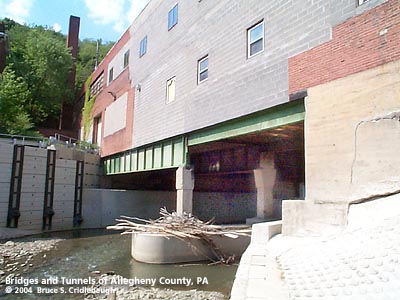
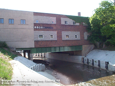
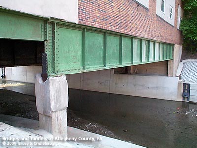
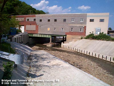
OFFICIAL NAME: OTHER DESIGNATION: 110 South Main St over Saw Mill Run A. Staab Co. Undertakers LOCATION: Pittsburgh USGS 7.5" Topo Quad - UTM Coordinates: Pittsburgh West - Zone 17; 0582 4477 CARRIES: former undertakers warehouse building BETWEEN: -- west of West End Circle -- Sanctus St CROSSES: -- Saw Mill Run TYPE OF CONSTRUCTION / DESIGN: plate girder LENGTH OF MAIN SPAN: 70 ft est TOTAL LENGTH (including longest elevated ramp): HEIGHT OF DECK: YEAR ERECTED / ENGINEER: pre-1916 ADDITIONAL INFO: Though there are many other locations where streams are covered over and buildings built upon them, this is one of the unusual instances where the building structure is obviously more bridge-like. The 1916 Hopkins plat map shows the A. Straab Co. Undertakers building as a masonry structure occupying two narrow lots and crossing over Saw Mill Run. The building at present is a patchwork of brick on each side of the stream with newer concrete block in the center. In 2001-3, an Army Corps of Engineers project included deepening, realignment and streambank stabilization of 4,700 feet of Saw Mill Run. The streambanks in this area are covered with Fabriform revetments -- double layered nylon fabric forms filled with concrete grout. view page - Other structures in the West End Valley FIELD CHECKED: 10-May-2004 INFO SOURCES: field check Submit info or inquiry - share some facts or ask a question. Introduction -- Nearby Structures Page created: Last modified: 13-Jul-2004 |
View Larger Map 
| ||
| copyright: © Bruce S. Cridlebaugh 1999-2008 All Rights Reserved | ||||