pghbridges.com

allegorical carving from Allegheny County Office Building; 1929-31; Stanley L. Roush, architect

BRIDGES AND
TUNNELS OF
ALLEGHENY
COUNTY,
PENNSYLVANIA

. . . . . . . . . . . . . . .
Introduction
. . . . . . . . . . . . . . .
What's New
. . . . . . . . . . . . . . .
Tours
. . . . . . . . . . . . . . .
Search
. . . . . . . . . . . . . . .
STRUCTURES
List by Location
List by Design
List by Name
List by Use
. . . . . . . . . . . . . . .
OTHER INFO
Articles
Bridge Basics
Regional Maps
. . . . . . . . . . . . . . .
Terminology
 : Engineering
 : Masonry
 : Metal
 : Bridge
 : Tunnel
 : Mapping
. . . . . . . . . . . . . . .
About This Site
Info Sources
Related Sites
Feedback
. . . . . . . . . . . . . . .

Home > All By Location regional map > Pittsburgh West > Ohio River Boulevard over Verner Av
photo of bridge
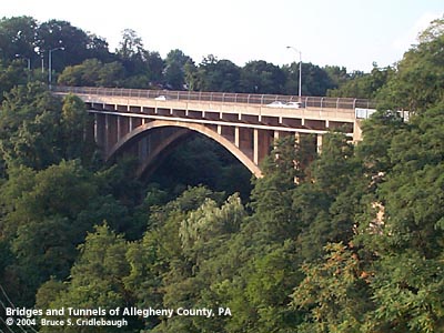
View northwest from Mckees Rocks Bridge
More detail photos
OFFICIAL NAME:

OTHER DESIGNATION:
Ohio River Boulevard over Verner Av

LOCATION:
Pittsburgh

USGS 7.5" Topo Quad - UTM Coordinates:
Pittsburgh West - Zone 17; 0581 4480


CARRIES:
Ohio River Boulevard [PA65]

BETWEEN:
-- Millerton Av
-- Termon Avenue Approach

CROSSES:
-- Verner Av


TYPE OF CONSTRUCTION / DESIGN:
Deck open spandrel concrete arch

LENGTH OF MAIN SPAN:
210 ft

TOTAL LENGTH (including longest elevated ramp):
390 ft

HEIGHT OF DECK:
80 ft est

YEAR ERECTED / ENGINEER:
1930, Allegheny County


ADDITIONAL INFO:


Mounted on the fence at the southwestern end of the bridge:

PITTSBURGH
OUTSTANDING CIVIL ENGINEERING ACHIEVEMENT AWARD
1985

{logo} American Society of Civil Engineers - Founded 1852

JACKS RUN BRIDGE - ROUTE 65 - ALLEGHENY COUNTY

COMMONWEALTH OF PENNSYLVANIA
DEPARTMENT OF TRANSPORTATION

Presented by the Pittsburgh Section, ASCE

from the PennDOT Historic Bridges Survey

"The bridge carries the 4 lane, Ohio River Boulevard (SR 65) over Verner Avenue in a wooded setting that gives way to modern, franchise commercial development and scattered highly altered early-20th century buildings. It was built as part of the Ohio River Boulevard, the highway designed to speed traffic to the McKees Rocks bridge. The highway has lost integrity due to alterations to its original geometry and roadside features as well as extensive modern development along it. Neither the highway nor the setting have historic district potential.

The 1930, 390'-long, reinforced concrete, ribbed, open spandrel arch has a 210'-long main span and slab approach spans supported on concrete abutments and concrete column and cap bents. About 1980 the bridge was widened by the removal of the original cantilevered deck sections and balustrades and placement of wider cantilevered deck sections with plain bracketed supports and safety shape barriers at the roadway curbs. The sidewalks are finished with chain link fence pedestrian barriers. Most of the columns have been shotcreted. Neither the bridge nor its setting and context are historically or technologically significant due to extensive alterations. It was determined not eligible by PHMC in 1986."


FIELD CHECKED:
17-Aug-2004

INFO SOURCES:
field check, PennDOT Historic Bridges Survey


Submit info or inquiry - share some facts or ask a question.

Introduction -- Nearby Structures

Last modified on 14-Oct-2004
copyright 1997-2004 Bruce S. Cridlebaugh