| Home > All By Location regional map > Pittsbugh East > Glenwood Bridge - B&O RR | |||
|
|
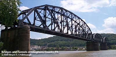
View southeast from Glenwood (downstream right) 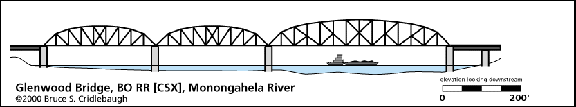
Elevation drawing looking downstream 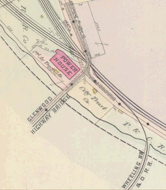
1904 map OFFICIAL NAME: Bridge Number 73, Pittsburgh Division, B&O Railroad OTHER DESIGNATION: Glenwood Bridge - B&O RR [CSX] pghe590-13 LOCATION: Pittsburgh USGS 7.5" Topo Quad - UTM Coordinates: Pittsburgh East - Zone 17; 0590 4472 CARRIES: CSX railroad, single track, footwalk BETWEEN: -- Glenwood [Glenwood Junction] on right descending bank of Monongahela River -- Hays on left descending bank of Monongahela River CROSSES: -- (RDB to LDB) CSX RR [B&O RR]; Monongahela River at mile 6.2; CSX RR [P&LE RR]; Sandcastle water amusement park access roads; NS RR [Conrail]; West 8th Av TYPE OF CONSTRUCTION / DESIGN: Pratt truss LENGTH OF MAIN SPAN: 453 ft TOTAL LENGTH (including longest elevated ramp): 2397 ft HEIGHT OF DECK: 50.5 ft, vertical clearance, channel span Emsworth Dam normal pool level 710 ft YEAR ERECTED / ENGINEER: 1884, upgraded 1915 American Bridge Company ADDITIONAL INFO: The Wheeling Division of the Baltimore and Ohio Railroad left the Pittsburgh-Cumberland mainline at Wheeling Junction, later reverting to its original name, Glenwood Junction. This single track line crosses the Monongahela River at Glenwood and follows the Streets Run valley southward, then heads southwest toward Wheeling. In 1928, the bridge traffic was reported as 19 freight trains and 12 passenger trains per day, carrying 7,333,580 tons and 219,000 passengers per year. Glenwood was the prinicpal yard for breaking up freight trains and classification of cars for local destinations, including the Water Street Yard near Grant St and First Av, the 36th St Yard on the south bank of the Allegheny River near Herr's Island, and the Willow Grove Yard on the north bank of the Allegheny below Millvale. The latter two yards were reached via Junction Hollow through Oakland. CSX continues to operate on these Pittsburgh Junction RR tracks today. The lines of the B&O railroad in Pittsburgh were originally built under the charter of other companies. The Pittsburgh and Connellsville Railroad was incorporated in 1837 and 1846, and the extension to Cumberland, MD, was completed in 1871. This is the CSX route along the north (right) bank of the Monongahela River. The 2.1 mile long Glenwood Railroad was opened in 1897 between Wheeling Junction (Glenwood) and Marion Junction (near the western end of Hazelwood, before Laughlin Junction at Four Mile Run). The Wheeling, Pittsburgh and Baltimore Railroad was constructed over the 66.5 miles from Wheeling Junction (Glenwood) by way of Washington, PA, to Wheeling, WV. It was completed in stages between 1851 and 1883. The route includes a tunnel under PA51 in Baldwin. Before a bridge over the Monongahela River was completed, ferry service made the connection until 1884. Six Mile Ferry operated from the end of the W.B. Hays and Brothers Coal RR which served the many mining operations of J.H. Hays in the Streets Run and Glass Run valleys. A pair of tracks served many spurs into the mines before the B&O was laid into the valley. The earlier bridge over the Monongahela River was modernized and upgraded with the present structure in 1915. FIELD CHECKED: 25-May-2000 INFO SOURCES: USACE Monongahela River Nav. Charts; Citizens Committee on City Plan of Pittsburgh. Railroads of the Pittsburgh district : a part of the Pittsburgh plan. Pittsburgh, Pa : Citizens Committee on City Plan of Pittsburgh, [1923], c1924; White & von Bernewitz, Bridges of Pittsburgh, 1928; 1876 Hopkins map. Submit info or inquiry - share some facts or ask a question. Introduction -- Nearby Structures Page created: Last modified: 05-Dec-2000 |
View Larger Map 
| |
| copyright: © Bruce S. Cridlebaugh 1999-2008 All Rights Reserved | |||