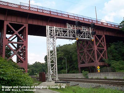
| Home > All By Location regional map > Pittsbugh East > South Millvale Av over PRR | |||
|
|

View east More detail photos OFFICIAL NAME: OTHER DESIGNATION: South Millvale Av over PRR South Millvale Av over Two Mile Run pghe589-10 LOCATION: Pittsburgh (Bloomfield - Shadyside) USGS 7.5" Topo Quad - UTM Coordinates: Pittsburgh East - Zone 17; 0589-4478 CARRIES: South Millvale Av BETWEEN: -- Morewood Av, north of Baum Blvd (Shadyside) -- Yew St, south of Liberty Av (Bloomfield) CROSSES: -- (north to south) Gross St; Two Mile Run ravine; two tracks Norfolk Southern RR (former PRR); Port Authority Busway TYPE OF CONSTRUCTION / DESIGN: Steel girder on trussed steel bent towers LENGTH OF MAIN SPAN: 87 ft est TOTAL LENGTH (including longest elevated ramp): 435 ft (total of five spans) [87 ft; 65 ft; 22 ft tower; 87 ft; 22 ft tower; 65 ft; 87 ft] HEIGHT OF DECK: 62 ft est 55 ft est clearance YEAR ERECTED / ENGINEER: 1927, City of Pittsburgh Public Works Department Independent Bridge Co. ADDITIONAL INFO: from the PennDOT Historic Bridges Survey: The 5 span, 435'-long, built up deck girder bridge built in 1927 is supported on ashlar abutments and wide, built up steel bent towers. It has steel railings with a reticulated pattern. Girder bridges are one of the most common bridge types in the state, first developed by the railroad industry in the 1840s and built in great numbers for both highway and railroad applications through the mid 20th century. Examples dating to before 1900 are not uncommon in the county. This bridge has no innovative or distinctive details. According to city records, it was built by the city to improve vehicular traffic flow, rather than by the railroad to improve its operations. It does not have a significant historic association with the development of the PHMC-determined eligible PRR Main Line. The bridge is not historically or technologicaly distinguished by its setting or context. The quote from the PennDOT Survey includes a pair of statements which are wrong or debateble at best. First, the northern abutment is concrete -- badly spalled -- not ashlar (cut stone); the southern abutment is not easily accessible, so the claim is not easily confirmed. Secondly, the built up trussed steel bents, girders, and especially the reticulated piecework railings are not so common within Allegheny County. Although the city added a chain-link fence along the deck, the railings and fixtures seem remarkably intact from the 1927 design. And the design of the fixtures is somewhat less intricate, but similar to the 1914 Bloomfield Bridge -- also built by the city and the next bridge crossing the Pennsylvania Railroad Main Line, one-half mile west. The Bloomfield Bridge crosses at milepost 350.73; South Millvale Av is at milepost 350.28. Without reference for the original design, it appears that the addition of the fencing and the installation of modern lamp fixtures are the only changes from its 1927 appearance. At the northeastern end of the bridge railing is an older style railing. Its design is also found along an older section (c1915) of the Blvd of the Allies near Forbes Avenue. This suggests that there may have been an earlier bridge crossing here. FIELD CHECKED: 13-Jun-2004 INFO SOURCES: field check; PennDOT Historic Bridges Survey Submit info or inquiry - share some facts or ask a question. Introduction -- Nearby Structures Page created: Last modified: 29-Jun-2004 |
View Larger Map 
| |
| copyright: © Bruce S. Cridlebaugh 1999-2008 All Rights Reserved | |||