| Home > All By Location regional map > Pittsbugh East > Pittsburgh Junction RR over Boundary St | |||
|
|
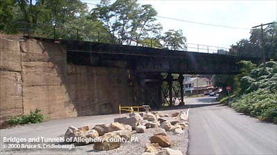
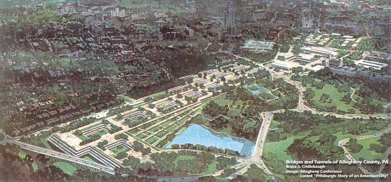
View from Panther Hollow Lake More detail photos OFFICIAL NAME: OTHER DESIGNATION: Pittsburgh Junction RR over Boundary St LOCATION: Pittsburgh (Four Mile Run) USGS 7.5" Topo Quad - UTM Coordinates: Pittsburgh East - Zone 17; 0589 4475 CARRIES: railroad; Pittsburgh Junction RR [CSX, former B&O] BETWEEN: -- CROSSES: -- Boundary St TYPE OF CONSTRUCTION / DESIGN: deck girder LENGTH OF MAIN SPAN: TOTAL LENGTH (including longest elevated ramp): HEIGHT OF DECK: YEAR ERECTED / ENGINEER: ADDITIONAL INFO: The Four Mile Run valley was formed as a prehistoric course for the Monongahela River. Its earlier name was given due to its distance from the Point in Pittsburgh. Part of the Four Mile Run valley splits into two major bottoms: one along Saline St [which was once a continuous street extending to the Saltworks on the Monongahela River across from Homestead] -- the other is Junction Hollow. The name Junction Hollow comes from the Pittsburgh Junction RR which was first laid through the 150-foot-deep valley in 1884-86. Part of the Baltimore and Ohio Railroad (CSX) mainline from Chicago, it linked raillines through Pine Creek valley (Etna) and Willow Grove rail yard on the north shore of the Allegheny River to (Pittsburgh Junction RR) Bloomfield Ravine and the tunnel under Neville St in Oakland to Junction Hollow (near Panther Hollow) and the Monongahela River at Laughlin Junction. Junction Hollow is sometimes confused with Panther Hollow: the former extends northward between the Carnegie Library and Museum and holds the railroad -- Panther Hollow branches northeastward below and behind the Phipps Conservatory. An extension of the Eliza Furnace Trail follows Junction Hollow to Joncaire St. The trail provides a recreational trail for biking, walking and skating and links Oakland to downtown Pittsburgh near Second Av and Grant St. The City has erected signs which give historical information about the area. One of those signs is near this bridge. The Eliza Furnace Trail follows the former right of way for the Baltimore & Ohio RR line into downtown Pittsburgh. The spur led from Laughlin Junction at Second Av and Greenfield Av to the passenger and freight terminal at Grant St and First Av [Water St Station and Water St Terminal]. At one time, the B&O considered building a freight yard and new passenger station in Junction Hollow as part of a plan to remove the tracks along Second Av to downtown. In the 1960s, the University of Pittsburgh and Carnegie Mellon University proposed to fill Junction Hollow with a complex of research and educational facilities. An illustration of this plan appeared in Lorant's "Pittsburgh." The Hollow remained empty, but nearby at the Monongahela River site of the Jones and Laughlin Eliza Furnace a similar cluster of buildings began to rise at the Pittsburgh Technology Center. Today, Boundary St in Junction Hollow has been closed between the Junction RR bridge at Four Mile Run and Joncaire St and the valley floor is being graded for soccer fields. FIELD CHECKED: 02-Oct-2000 INFO SOURCES: Submit info or inquiry - share some facts or ask a question. Introduction -- Nearby Structures Page created: Last modified: 07-Dec-2000 |
View Larger Map 
| |
| copyright: © Bruce S. Cridlebaugh 1999-2008 All Rights Reserved | |||