| Home > All By Location regional map > Pittsbugh East > Parkway East pedestrian bridge at South Oakland | |||
|
|
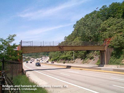
View west, 2001 More detail photos OFFICIAL NAME: OTHER DESIGNATION: Pedestrian Walkway #1 Parkway East pedestrian bridge at South Oakland Parkway East pedestrian bridge at Bohem St LOCATION: Pittsburgh USGS 7.5" Topo Quad - UTM Coordinates: Pittsburgh East - Zone 17; 0588 4475 CARRIES: -- pedestrians BETWEEN: -- Second Av, west of Swinburne St (formerly Sylvan Av) -- Bohem St (formerly Blane St), South Oakland CROSSES: -- Parkway East [I-376, US22, US30]; Eilza Furnace recreational trail [former B&O RR]; Second Av TYPE OF CONSTRUCTION / DESIGN: Parkway East span: haunched riveted steel girder on concrete piers Eliza Furnace trail span: reinforced concrete beam Second Av span: bolted steel girder LENGTH OF MAIN SPAN: Parkway East span: 101 ft TOTAL LENGTH (including longest elevated ramp): HEIGHT OF DECK: YEAR ERECTED / ENGINEER: 1951 ADDITIONAL INFO: The bridge was removed in June 2006. Before the Parkway East cut along the hillside above Four Mile Run, several of the streets from South Oakland descended to meet Second Av near the Jones and Laughlin steel works. The 1904 Hopkins plat maps show Blaine St (now Bohem St) continue over the hillside with steps accompanying. The highway, built in this area between 1951 and 1953, removed all of the streets and houses which clung to the hillside between the Baltimore and Ohio RR and the South Oakland bluff. This combination of three spans and a concrete stairway common on Pittsburgh's hillsides allowed continued access for workers living above to their workplaces below. The structure is best viewed as four separate components. Each seems to have been built by the authority responsible for what it crossed over. Starting at Second Av, a collection of light steel girders carries an even lighter deck. The open grating of each stair tread is in reasonable condition although a railing has been welded across the entrance at the street. The span over the former B&O RR features heavier railroad-type of construction. Although the beams and bents seem intact, the floor does not feel as solid. Trees bend in to cover the short flights of stairs leading to the base of the southern concrete stair tower aside the Parkway. The bridge over the highway is the best preserved structure of the group. The view to the south and west is an excellent panorama of the South Side and the reverse angle of most Pittsburgh skyline postcards. From the bridge, one is able to enjoy the view which is usually seen at high speeds from the road. Chain link fences installed to prevent vandals from attacking passing traffic provide the canvas for this bridge's most visible role: posting of political signs. Beyond the Parkway span, a long flight of concrete stairs -- a signature item on the city of Pittsburgh tree-covered hillsides -- climbs to South Oakland. The treads are missing or broken in some places; trees and honeysuckle vines choke the path. A fallen tree blocks the path completely near the top of the bluff. FIELD CHECKED: INFO SOURCES: Submit info or inquiry - share some facts or ask a question. Introduction -- Nearby Structures Page created: Last modified: 14-Jun-2006 |
View Larger Map 
| |
| copyright: © Bruce S. Cridlebaugh 1999-2008 All Rights Reserved | |||