| Home > All By Location regional map > Pittsbugh East > Birmingham Bridge | ||||
|
|
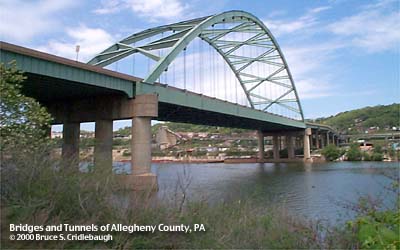
View north from Riverfront Park 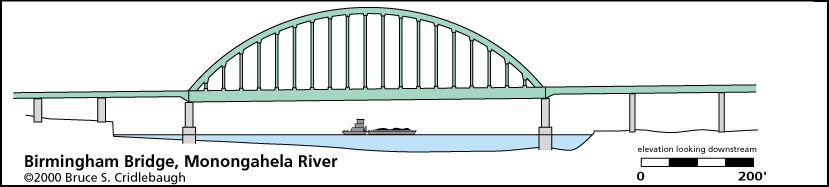
Elevation drawing looking downstream
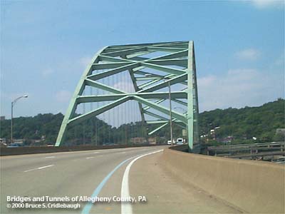
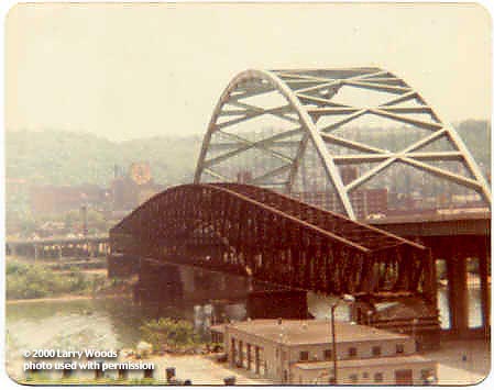
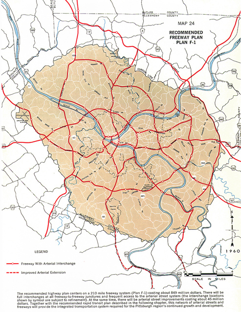
Birmingham Bridge OTHER DESIGNATION: pghe587-22 LOCATION: Pittsburgh USGS 7.5" Topo Quad - UTM Coordinates: Pittsburgh East - Zone 17; 0587 4476 CARRIES: motor vehicles, 6 lanes divided BETWEEN: -- connections to Fifth Av and Forbes Av on right descending bank of Monongahela River -- East Carson St between South 22nd St and South 23rd St on left descending bank of Monongahela River CROSSES: -- (RDB to LDB) Brady St; Penn Lincoln Parkway East [I-376], Forbes Av and Blvd of Allies ramps; Second Av; Monongahela River at mile 2.4; River Front Park; CSX RR tunnel TYPE OF CONSTRUCTION / DESIGN: Steel bowstring arch, wire rope suspenders; welded beam approach spans LENGTH OF MAIN SPAN: 607 ft TOTAL LENGTH (including longest elevated ramp): 1662 ft HEIGHT OF DECK: 64.8 ft, vertical clearance, channel span Emsworth Dam normal pool level 710 ft YEAR ERECTED / ENGINEER: 1976, Buchart Horn Inc., PennDOT ADDITIONAL INFO: Like a shirt that doesn't shrink, but you never quite grow into, the Birmingham Bridge looms above the Monongahela River. This bridge stands adjacent to (downstream from) the former site of the Brady Street Bridge at South Twenty-Second Street. That 1896 bridge was the first toll free river crossing in Pittsburgh and served to connect the local streets on each side of the river. More info about that bridge is also here. (Historic American Engineering Record) An icon for plans that never materialized, the Birmingham Bridge was massively overbuilt in anticipation of an innercity belt highway. The 1963 map shows a highway system laid over the Pittsburgh area which would have used the Birmingham Bridge as a connection between the Mon Valley and PA28 in the Allegheny Valley. Some of the ghost ramps still show as stubs on the southern approach. When those plans were abandoned the ramps were redesigned to make the best of the existing streets. On the north end at the junction of Uptown, the Hill and South Oakland, ramps at the main span deck level link to Fifth Avenue which lead one way into downtown; ramps from Forbes Avenue, one way out of downtown, angle upward to meet the deck; a remnant of the old Brady Street pokes its way through the steel bents to find a path down to Second Avenue. On the South Side, the indecision is apparent as the ramps bend strangely to land at East Carson Street in Birmingham between South 22nd and South 23rd Streets. For nearly 1700 feet, this six-lane highway appears to be heading somewhere, but ends at abrupt T-intersections. Although the northern ramps deftly thread their way through the Penn Lincoln Parkway, there is no connection. Access from the Parkway to the South Side from the East requires use of the Bates Street exit (Glenwood 7B - PA885 South) and Second Avenue, then tracing up through a maze of steel bents and substructure below the Birmingham Bridge. Access from the westbound Parkway to the South Side is even more tortured; neither the Grant Street exit nor the Oakland exit provide simple connections to the streets leading to the bridge. With the Mon-Fayette Expressway project coming to Pittsburgh, many expect the Birmingham Bridge to finally have connections that make sense for its size. But most of the possible routes being studied do not seem to hold out much hope for integrating the "green elephant." Below the bridge on the South Side, River Front Park stretches along the bank of the Monongahela River from its entrance at South 18th Street upstream to a point near the Hot Metal Bridge and the South Side Works redevelopment area. This strip of greenway between the CSX railroad and the river features willow-shaded park areas and a public boat launching ramp. And an excellent viewing location for admiring the Birmingham Bridge structure. FIELD CHECKED: 10-May-2000 INFO SOURCES: USACE Monongahela River Nav. Charts Submit info or inquiry - share some facts or ask a question. Introduction -- Nearby Structures Page created: 29-Aug-2001 Last modified: 25-Dec-2013 |
View Larger Map 
| ||
| copyright: © Bruce S. Cridlebaugh 1999-2008 All Rights Reserved | ||||