| Home > All By Location regional map > Pittsbugh East > Herr's Island Railroad Bridge | |||
|
|
Downstream right 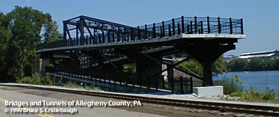
Bike trail ramps added at River Ave 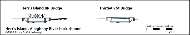
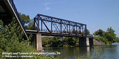
Elevation drawing looking downstream OFFICIAL NAME: West Penn Railroad Bridge OTHER DESIGNATION: Herr's Island Railroad Bridge South Railroad Bridge pghe586-14 LOCATION: Pittsburgh USGS 7.5" Topo Quad - UTM Coordinates: Pittsburgh East - Zone 17; 0586 4479 CARRIES: Three Rivers Heritage Trail - pedestrians BETWEEN: -- near River Av on right descending bank of Allegheny River -- downstream tip of Washington's Landing (Herr's Island) in Allegheny River CROSSES: -- back channel of Allegheny River at mile 2.4 TYPE OF CONSTRUCTION / DESIGN: Iron? Pratt truss LENGTH OF MAIN SPAN: 64 ft TOTAL LENGTH (including longest elevated ramp): 150 ft est. HEIGHT OF DECK: 30 ft est. Emsworth Dam normal pool level 710 ft YEAR ERECTED / ENGINEER: 1903, Pennsylvania Railroad (Western Pennsylvania Railroad) replaced 1890 structure ADDITIONAL INFO: This former PRR railroad bridge at the downstream tip of the island linked the railroad at "CQ" tower on the north shore to a loop servicing the stockyards and meat packing plants on Herr's Island. It appears to be one of the oldest surviving river bridges in the area. It employs vertical end posts in a manner similar to covered bridge trusses; most truss bridges built after the 1880s used inclined end posts at the portals. Web members are pin-connected eyebars with tension rods in the center panels and lattice vertical posts. The only markings on the bridges are faded diagonal paint stripes and a sign to warn of close clearance. This bridge has been converted to pedestrian use, and includes an accessible switchback ramp at its western end. Reopened in June 1999, it was rehabilitated as part of the Three Rivers Heritage Trail. This trail is a bike/hike trail which is linked to several others which line the rivers of Pittsburgh and connect to the Great Allegheny Passage and C&O Canal Trail which extend along the Youghiogheny River and Potomac River to Washington DC. Other sections in Pittsburgh include the Eliza Furnace Trail ("Jail Trail") and Steel Heritage Trail on the Monongahela River; the Yough Trail; the Montour Trail, a former rail line through the western section of Allegheny and Washington counties. Trail Map At the downstream tip of the island a small park provides a stone benches, a stepping stone compass-map representing the three rivers and Herr's Island inlaid into the crushed limestone path. From this location. Pittsburgh's eastern skyline rises above the Allegheny River and the triple-arched Sixteenth Street Bridge. The island was settled by Benjamin Herr who operated a water powered mill in the back channel. Federal regulations required that livestock being transported by railroad must be given rest stops. Stockyards were constructed on Herr's Island. Over time, the stockyards were expanded; slaughterhouses and processing factories covered the island. Later the stockyards were closed and replaced by warehouses. Sculling teams from local universities discovered the still waters of the back channel and used this area for training. Herr's Island was rechristened Washington's Landing by the City of Pittsburgh as part of the clean-up and rehabilitation of the former industrial brownfield site. A new 30th Street bridge was built for reliable access by vehicles. With the raised environmental conciousness of the early 1990s, Herr's Island was rediscovered, cleared and cleaned as part of a residential and recreational development which includes a marina, recreational trails and riverside park areas. view page - Historic American Engineering Record document PA-443 FIELD CHECKED: 19-Aug-1999 INFO SOURCES: USACE Allegheny River Nav. Charts; Three Rivers Heritage Trail signage; HAER Submit info or inquiry - share some facts or ask a question. Introduction -- Nearby Structures Page created: Last modified: 15-Mar-2008 |
View Larger Map 
| |
| copyright: © Bruce S. Cridlebaugh 1999-2008 All Rights Reserved | |||