| Home > All By Location regional map > Pittsbugh East > Panhandle Tunnel | |||
|
|
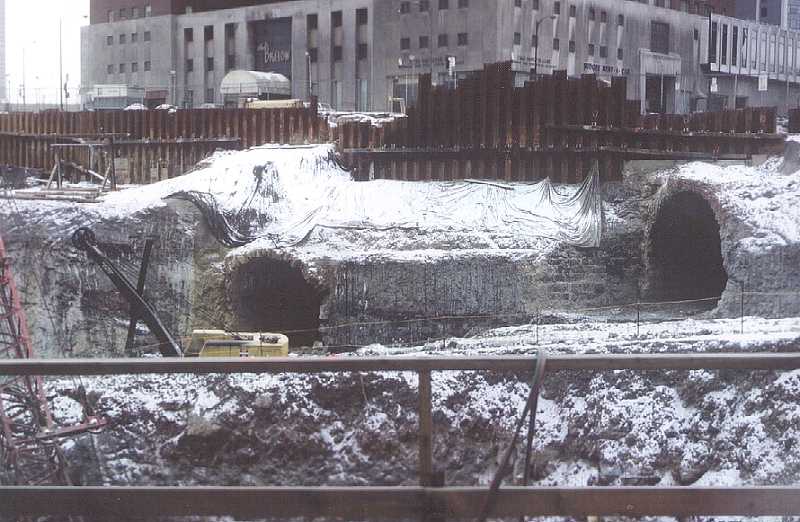
Photo by Bob Rathke, 2/11/68, PA canal tunnel (left) and Panhandle RR tunnel during construction of U.S. Steel Building [USX Tower] Panhandle Tunnel - Detail photos Panhandle Tunnel - Historic American Engineering Record documentation Steel Plaza Subway Station OFFICIAL NAME: Pittsburgh & Steubenville Extension Railroad Tunnel OTHER DESIGNATION: Panhandle Tunnel LOCATION: Pittsburgh USGS 7.5" Topo Quad - UTM Coordinates: Pittsburgh East - Zone 17; 0585 4477 CARRIED: Pittsburgh & Steubenville Extension RR; Pittsburgh, St. Louis, Cincinnati & Chicago RR (Panhandle RR); Pennsylvania RR converted 1983-85 as part of Port Authority "T" subway BETWEEN: --Union Station (Grant St at Liberty Av) -- northern portal: east of Strawberry Wy at Grant St (under USX Tower) -- southern portal: between High St and Tunnel St [Chatham St], north of Watson's Rd [Forbes Av] -- Panhandle Divison PRR at Try St to Panhandle Bridge over Monongahela River UNDER: Grant's Hill TYPE OF CONSTRUCTION / DESIGN: cut and cover; cut stone lower walls; 5-ring brick arch; horseshoe profile TOTAL LENGTH: 930 ft (approximate original tunnel) 1,438.6 ft (after additions and reconstruction) OTHER DIMENSIONS: Original tunnel arch rise: 21.5 ft First Forbes Av addition arch rise: 19.5 ft Second Forbes Av addition arch rise: 18.5 ft Original tunnel width at spring line: 24 ft Single track section below USX Tower: 17.4 ft wide YEAR OPENED / ENGINEER: 1863, P&S RR 1983-85, Port Authority of Allegheny County ADDITIONAL INFO: from the HAER report: "Original plans detailing tunnel construction are not available; however, one profile drawing, dating to October 28, 1901, has been located, which shows a double track tunnel of cut stone and brick construction with no invert (flat floor). The lower courses are cut stone, the upper courses consist of five rings of brick measuring a total of twenty-two inches thick. The walls beneath the spring line, the point where the curved arch meets the vertical wall, are shown to slope inward with a six to one batter, i.e., the inner face of the tunnel wall slopes inward one foot for every six vertical feet. The walls are shown to be supported by footers." view page - Historic American Engineering Record document FIELD CHECKED: INFO SOURCES: Historic American Engineering Record Submit info or inquiry - share some facts or ask a question. Introduction -- Nearby Structures Page created: Last modified: 27-Sep-2001 |
View Larger Map 
| |
| copyright: © Bruce S. Cridlebaugh 1999-2008 All Rights Reserved | |||