| Home > All By Location regional map > Pittsbugh East > Panhandle RR Bridge 1863 | ||||
|
|
View downstream toward Mount Washington 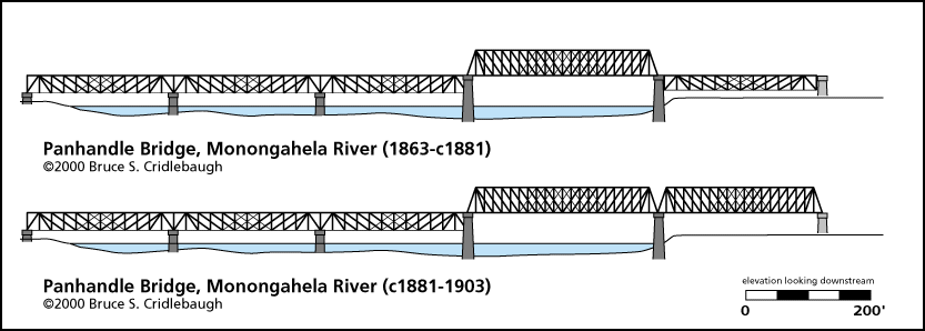
Elevation drawing looking downstream
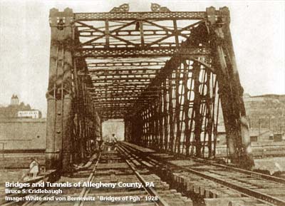
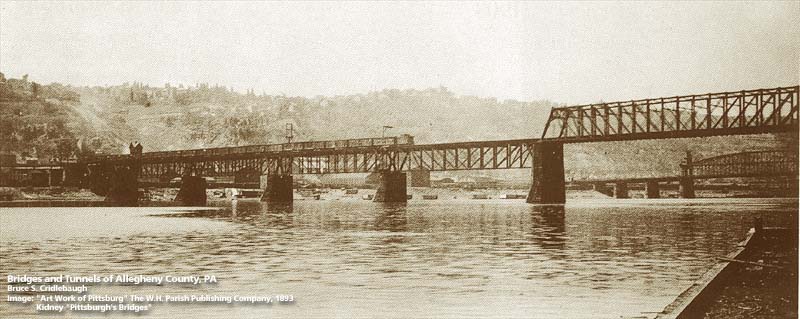
OFFICIAL NAME: Monongahela River Bridge OTHER DESIGNATION: Panhandle Bridge pghe584-67 LOCATION: Pittsburgh USGS 7.5" Topo Quad - UTM Coordinates: Pittsburgh East - Zone 17; 0584 4476 CARRIES: Port Authority of Allegheny County (PAT) "T" light rail system -- two tracks originally built for Pennsylvania Railroad "Panhandle" Division (see additional info below) BETWEEN: -- near Try St on right descending bank of Monongahela River -- near intersection of East Carson St and Arlington Av on left descending bank of Monongahela CROSSES: (RDB to LDB) north approach: Second Av; First Av main spans: Eliza Furnace ("Jail Trail") bike/hike trail [formerly BO RR yard]; Penn Lincoln Parkway East [I-376, US22, US30]; Monongahela River at mile 1.0 south approach, west wye branch: CSX RR (PLE); McKean St; East Carson St south approach, east wye branch: CSX RR (PLE); McKean St; South First St; East Carson St TYPE OF CONSTRUCTION / DESIGN: north approach: (north to south) steel pony riveted plate girder (simple span); steel deck riveted plate girder trestle (seven spans); steel pony riveted plate girder (simple span); concrete viaduct (solid); steel deck riveted plate girder trestle (two spans); steel pony riveted plate girder (simple span) main spans: (north to south) steel camelback Pratt through truss; Pennsylvania Pratt through truss (channel span); Pennsylvania Pratt through truss; steel Warren deck truss (two span continuous); south approach, west wye branch: steel plate deck girder (nine spans) south approach, east wye branch: steel deck plate girder (nine spans) LENGTH OF MAIN SPAN: 351 ft clearance channel span TOTAL LENGTH (including longest elevated ramp): HEIGHT OF DECK: 43.9 ft clearance Emsworth Dam normal pool level 710 ft YEAR ERECTED / ENGINEER: 1903, Pennsylvania Railroad American Bridge Company, S. P. Mitchell, engineer of erection; H. A. Greene, manager of western division, and James Sheedy, superintendent of erection ADDITIONAL INFO: This rail line was part of the route built by the Pittsburgh and Steubenville Railroad Company, a division of the Pittsburgh, Cincinnati, Chicago and St. Louis Railroad. The "Steubenville Extension" was later absorbed into the Pennsylvania Railroad. This line ran west to Steubenville, OH, crossing the "panhandle" of Virginia (West Virginia after the Civil War), thus the source of the nickname of the railroad and the bridge. The first bridge was built in 1863 and crossed the river via seven main spans, similar in length and position as current bridge; possibly Pratt trusses (parallel chords), each was a deck truss-type except the channel span (second from the northern end) which was a through truss. The bridge deck of 1863 structure was at the same elevation as downtown streets in the area and required grade crossings including Second St near the Try St Yard (site of Crosstown Blvd) and Fourth St Station (across Forbes Av [then Diamond St] from the old jail). Old drawings and photographs show a structure with only one through truss before about 1881. A second through truss replaced the northernmost span. Drawing of previous bridge The current Panhandle Bridge was built in 1903. It was raised up as part of a grade separation project, 1912-1914. At the north approach, Second Av and the B&O Railroad were lowered and a series of plate girder spans were constructed to carry the Panhandle Division of the PRR from the bridge past Fourth St Station and into Tunnel No. 1 which leads to Pennsylvania Union Station at Liberty and 11th St. Since 1985, this route has been used as part of the "T" light rail system operated by the Port Authority of Allegheny County. The above ground light rail vehicles cross the Panhandle Bridge, pass under several buildings and enter the PRR tunnel under Forbes Av -- thereby entering the Pittsburgh subway. The south approach to the Panhandle Bridge splits after crossing the Monongahela River. This was the location of the Monon Tower ("MB"). Evidence of the original connections from the wye to the PRR (later Conrail, now Norfolk Southern) may be found in the old abutments, massive stone walls and repurposed piers. The single-track eastern (upstream) branch of the wye led to the Monongahela Division of the PRR; it now connects to the Arlington line of the "T" light rail system on new deck and piers which rise higher than the PRR previously. The double-tracked western branch of the wye continued as the Panhandle Divison of the PRR; it led to a station at Smithfield St above the current location of the "T" light rail station near Station Square. The "T" line descends to this street-level station at East Carson and Smithfield Streets, then curves into the Mt Washington Trolley Tunnel. Several of the original piers near the river were refurbished while those nearer to East Carson St were built in 1985 view page - Panhandle Bridge Wye -- southern approach The north approach is near the south portal of the Pennsylvania Canal tunnel, lift locks along the present Try St (Front St, Second St, Fourth St) and the Mon River outlet. This area is also the former location of Pipetown at Suke's Run (also called Sucks Run). Nathaniel Greenough operated a shipyard here. The section of First Av (also known at Front St) east of Try St was once called Greenough St. FIELD CHECKED: 24-Jun-1999 INFO SOURCES: USACE Monongahela River Nav. Charts; Kobus and Consoli, "The Pennsy in The Steel City" and "The Pennsylvania Railroad's Golden Triangle;" Lorant: "Pittsburgh: The Story of an American City;" Geographia Map Co.: "Ideal Atlas of Pittsburgh;" Kidney: "Pittsburgh's Landmark Architecture"; 1999 photos by Jon Bell Submit info or inquiry - share some facts or ask a question. Introduction -- Nearby Structures Page created: Last modified: 02-Nov-2001 |
View Larger Map 
| ||
| copyright: © Bruce S. Cridlebaugh 1999-2008 All Rights Reserved | ||||