| Home > All By Location regional map > McKeesport > McKeesport Connecting RR Bridge | |||
|
|
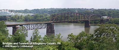
View south from PA837 (downstream left) Elevation drawing looking downstream More detail photos OFFICIAL NAME: OTHER DESIGNATION: Union Railroad Bridge Riverton Bridge McKeesport Connecting Railroad Bridge mcke597-1 LOCATION: Duquesne - McKeesport USGS 7.5" Topo Quad - UTM Coordinates: McKeesport - Zone 17; 0597 4467 CARRIES: Union RR, railroad single track BETWEEN: -- former PRR; USX National Tube Works site on right descending bank of Monongahela River -- former B&O RR; USX Duquesne Works on left descending bank of Monongahela River CROSSES: -- (RDB to LDB) National Tube Works site; Monongahela River at mile 14.3; Union RR TYPE OF CONSTRUCTION / DESIGN: Parker/Pratt through trusses; Pratt deck trusses; trestle LENGTH OF MAIN SPAN: 324.0 ft TOTAL LENGTH (including longest elevated ramp): HEIGHT OF DECK: 49.1 ft, vertical clearance, channel span Lock and Dam No. 2, Braddock, normal pool level 718.7 ft YEAR ERECTED / ENGINEER: 1890 ADDITIONAL INFO: This bridge is shown on various maps under the control of various railroads over time, including the PRR and Conrail. It connected the PRR [Conrail] on the left bank of the Mon River with the B&O RR [PLE RR, CSX] on the right bank. It provided the rail connection between the National Tube Works at McKeesport and the USS Dorothy Six blast furnace of the Duquesne Works. Both of those major industrial plants are now for the most part demolished -- each being redeveloped by the Regional Industrial Development Corporation of Southwestern Pennsylvania as industrial-business parks. "RIDC is a private, non-profit economic development corporation established in 1955 by the business, corporate, governmental and labor leaders of that time. (Their) mission is to provide diversified economic development services." National Tube became Riverplace Industrial Center of McKeesport; The Duquesne Works became Riverplace City Center of Duquesne. More info on these RIDC projects (Western PA Brownfields Center): McKeesport (PDF) Duquesne (PDF) FIELD CHECKED: 03-June-2000 INFO SOURCES: USACE Monongahela River Nav. Charts Submit info or inquiry - share some facts or ask a question. Introduction -- Nearby Structures Page created: Last modified: 13-Mar-2008 |
View Larger Map 
| |
| copyright: © Bruce S. Cridlebaugh 1999-2008 All Rights Reserved | |||