| Home > All By Location regional map > McKeesport > Liberty Way over Heath's Run | |||
|
|
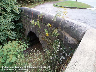
View southeast (upstream to right) 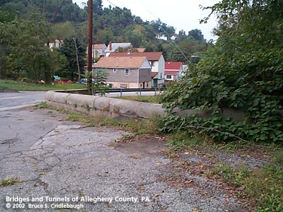
View northwest from Liberty Way toward Glenn Av OFFICIAL NAME: OTHER DESIGNATION: Liberty Way over Heath's Run mcke596-5 LOCATION: Liberty USGS 7.5" Topo Quad - UTM Coordinates: McKeesport - Zone 17; 0596 4464 CARRIES: -- Liberty Way BETWEEN: -- adjacent to intersection with Glenn Av (Glenn Av parallels Heath's Run toward Youghiogheny River) CROSSES: -- Heath's Run TYPE OF CONSTRUCTION / DESIGN: stone arch locally-quarried sandstone outer spandrel wall: rock-faced coursed ashlar upper walls and parapets: dressed coursed ashlar arch ring: dressed voussoirs in semi-circular arch Southern (downstream) wall is original stonework; Bridge was widened and northern stonework replaced. LENGTH OF MAIN SPAN: 10 ft TOTAL LENGTH (including longest elevated ramp): HEIGHT OF DECK: YEAR ERECTED / ENGINEER: County of Allegheny Charles Davis, county engineer ADDITIONAL INFO: During years surrounding 1900, Allegheny County, under the direction of County Engineer Charles Davis, was busy throughout the county building stone arch bridges of a simple and similar design. This bridge exhibits the more common design features of the County's stone bridges -- parapets with rounded top and horizontal curves at the portals. Southern (downstream) wall is original stonework; bridge was widened and northern stonework replaced. Heath's Run forms the border between Liberty Borough and Port Vue. FIELD CHECKED: 29-Sep-2002 INFO SOURCES: field check Submit info or inquiry - share some facts or ask a question. Introduction -- Nearby Structures Page created: Last modified: 03-Feb-2003 |
View Larger Map 
| |
| copyright: © Bruce S. Cridlebaugh 1999-2008 All Rights Reserved | |||