| Home > All By Location regional map > Glenshaw > Wetzel Rd over Little Pine Creek | |||
|
|
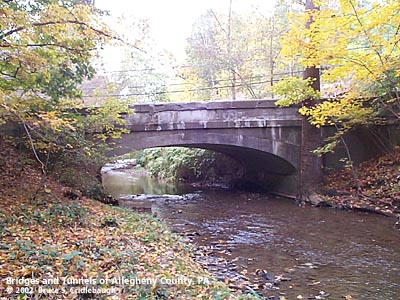
View north (upstream) More detail photos OFFICIAL NAME: OTHER DESIGNATION: Wetzel Rd over Little Pine Creek glen587-24 LOCATION: Shaler USGS 7.5" Topo Quad - UTM Coordinates: Glenshaw - Zone 17; 0587-4486 CARRIES: Wetzel Rd [SR 4017] BETWEEN: -- west of Little Pine Creek Rd CROSSES: -- Little Pine Creek TYPE OF CONSTRUCTION / DESIGN: Closed spandrel concrete arch; Parapet walls: concrete formed modules LENGTH OF MAIN SPAN: 31 ft TOTAL LENGTH (including longest elevated ramp): HEIGHT OF DECK: YEAR ERECTED / ENGINEER: 1936, Allegheny County ? ADDITIONAL INFO: Wetzel Rd is a twisting shortcut of a road between Wible Run Rd and Mt. Royal Blvd. Many of the roads in this part of the North Hills follow the contours established by the stream valleys which generally run north-south radiating from the Allegheny River. Only a few obvious east-west connectors are apparent; because Wetzel Rd is somewhat secluded, it seems to be one of those secrets known mainly by those who live in the area. And the Little Pine Creek Valley here has escaped most development -- one may forget the nearness of some of the suburban neighborhoods and commercial strips. Wetzel Rd is listed as SR 4017, indicating it is maintained by PennDOT. But the characteristics of this bridge seem to match many others built between c1910 and c1936 by the Allegheny County Public Works Department. During years surrounding 1900, Allegheny County, under the direction of County Engineer Charles Davis, was busy throughout the region building stone arch bridges of a simple and similar design. Typically, they featured parapets with rounded top and slightly enlarged parapet endcaps. Beginning about 1910 -- after Chalfant assumed the position of County Engineer -- new county bridges of this size were being constructed solely in concrete using a design which mimicked the earlier stone arches. On a few of the concrete structures, a builder's plate identifies the bridge as having been constructed by Allegheny County and includes the stream name and date. Several bridges of this design are found throughout Allegheny County, but usually without the builder's plate to confirm the date or the authority in charge of construction. The similar of design and construction seems to imply that they were all built by Allegheny County, and other sources state construction dates to about 1936. This arched design was phased out and replaced by simpler beam bridges. The arch portion of the bridge seems reasonably intact, but the parapet walls are severely crumbling. Examination of the other bridges of this design show a similar pattern. The parapets appear to have been constructed by stacking a series of formed concrete modules. The modules were shaped to mimic the rounded caps found on County bridges designed by Davis. Each block seems to have weathered differently and the seams between them allowed further decay. The Old Butler Plank Rd bridge over Gourhead Run is possibly the best preserved example. The closed spandrel walls and outer faces of the parapets have recessed panels which further echo the designs from the County's earlier stone arch bridges. The parapets are most similar to those created in stone for Merriman Rd over Big Sewickley Creek. This bridge carrying Wetzel Rd over Little Pine Creek seems to be one of the last of its design built locally. FIELD CHECKED: 21-Oct-2002 INFO SOURCES: field check Submit info or inquiry - share some facts or ask a question. Introduction -- Nearby Structures Page created: Last modified: 17-Apr-2003 |
View Larger Map 
| |
| copyright: © Bruce S. Cridlebaugh 1999-2008 All Rights Reserved | |||