| Home > All By Location regional map > Glassport > Cochran's Mill Rd over Licks Run | ||||
|
|
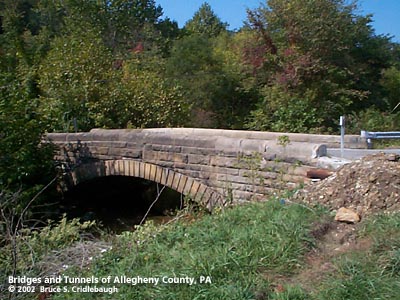
View northwest (upstream)
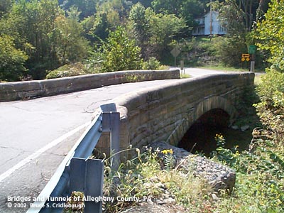
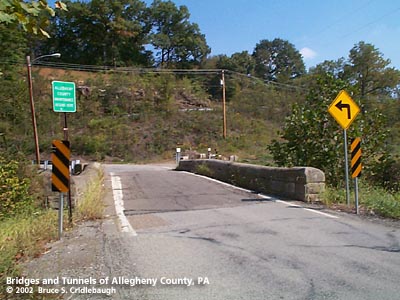
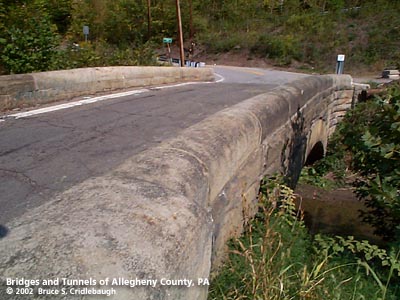
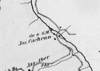
OFFICIAL NAME: Cochran's Mill Rd over Licks Run OTHER DESIGNATION: Snowden Rd over Licks Run glas587-28 LOCATION: South Park Twp - Jefferson Hills USGS 7.5" Topo Quad - UTM Coordinates: Glassport - Zone 17; 0587 4460 CARRIES: -- Cochrans Mill Rd [AC# 5045]; Snowden Rd [SR3015] BETWEEN: -- Cochrans Mill Rd [AC# 5045] -- Snowden Rd [SR3015] CROSSES: -- Licks Run (aka Lick Run) TYPE OF CONSTRUCTION / DESIGN: stone arch locally-quarried sandstone outer spandrel wall: rock-faced coursed ashlar upper walls and parapets: dressed coursed ashlar arch ring: dressed voussoirs in segmental arch LENGTH OF MAIN SPAN: 24 ft TOTAL LENGTH (including longest elevated ramp): 52 ft 14.5 ft wide, between parapets HEIGHT OF DECK: YEAR ERECTED / ENGINEER: 1901, Allegheny County Charles Davis, County Engineer ADDITIONAL INFO: This bridge exhibits the more common design features of the County's stone bridges -- parapets with rounded top and horizontal curves at the portals. This bridge is listed as stone arch bridge S-2 in the Pennsylvania Historical and Museum Commission survey of PennDOT bridges which have significant historical value. The structure is described as "segmental arch of high quality rock, faced ashlar construction; voussoirs dressed; parapet finished with curved course." The survey entry reports the date as 1901. The 1876 Hopkins map shows the saw and grist mill of Joseph Cochran on Lick Run just upstream from this bridge. The mill race -- the water diverted from the stream to power the mill -- ran to the west of the stream, through the mill near the western end of the bridge site. This Cochran's Mill is not to be confused with another place of the same name also nearby in PA. Nellie Bly (Elizabeth Jane "Pink" Cochran) was born at Cochran's Mill in Armstrong County. This bridge may be threatened with replacement. A 1997 PA Senate Bill (186 P.N. 445) lists an appropriation for $215,000. (Base Construction Allocation - $150,000); (Land Allocation - $5,000); (Design and Contingencies - $60,000). The ownership of the bridge is not clear from the signs posted nearby. Small white markers, typical of PennDOT's secondary roads, indicate the bridge is part of SR3015. But a green sign claims "Allegheny County Maintenance Begins Here" to indicate that the bridge may be part of County Road 5045, aka Cochran's Mill Rd. The Senate Bill lists it as a Local Bridge as opposed to State. FIELD CHECKED: 28-Sep-2002 INFO SOURCES: field check; Historic Highway Bridges in Pennsylvania. Commonwealth of Pennsylvania, Pennsylvania Historical and Museum Commission, Pennsylvania Department of Tranportation, 1986. Submit info or inquiry - share some facts or ask a question. Introduction -- Nearby Structures Page created: 14-Oct-2002 Last modified: 19-Jun-2013 |
View Larger Map 
| ||
| copyright: © Bruce S. Cridlebaugh 1999-2008 All Rights Reserved | ||||