| Home > Articles > Pennsylvania Path of Progress | |||
|
|
Pennsylvania Path of Progress
The Path of Progress National Heritage Tour Route is a 500-mile driving route that extends through nine southwestern Pennsylvania counties and links heritage sites. A federally-designated National Heritage Area, it directs visitors to key historical sites and points of interest, including four National Park Sites. Heritage sites pertain to the westward expansion of the early United States across the Allegheny Mountains, early settlement, battlefields, farming, the switch from an agrarian to an industrial society, and the Industrial Age. 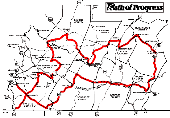
Events and sites represented include: the French and Indian War, Pontiac's Rebellion, the National Road, the Pennsylvania Canal and the Allegheny Portage Railroad, the Altoona Railroaders Museum and Horseshoe Curve, the Lincoln Highway, coal mining, steel and coke production, related industries such as aluminum and glass, the Johnstown Flood, Fallingwater, and more. It was also an early source of information about hiking trails and rails-to-trails bike paths. 
 The signage for the main loop features two signs: the round outside shape indicates travel in a counterclockwise direction (looking down at a map). The square outside shape indicates travel in a clockwise direction.
There are additional spurs and loops along the main route. Each county has one or more loops or extensions. These are not marked by signs, but appear on maps which are available at many of the major sites along the main route. Sites listed on a mid-1990s map (county): 1. Bushy Run Battlefield (Westmoreland) 2. Fort Ligonier (Westmoreland) 3. Fort Necessity National Battlefield (Fayette) 4. Fort Roberdeau (Blair) 5. Friendship Hill NHS (Fayette) 6. Fallingwater (Fayette) 7. Nemacolin Castle (Fayette) 8. Linden Hall (Fayette) 9. Old Bedford Village (Bedford) 10. Somerset Historical Center (Somerset) 11. West Overton Museum (Westmoreland) 12. Burnt Cabins Grist Mill (Fulton) 13. Allegheny Portage Railroad NHS (Cambria) 14. Saltsburg Canal Park (Indiana) 15. Cambria Iron Company (Cambria) 16. Limestone Kilns, Canoe Creek (Blair) 17. Eliza Furnace (Cambria) & Mt Etna Furnace (Huntingdon) 18. Horseshoe Curve (Cambria) 19. East Broad Top Railroad (Huntingdon) 20. Gallitzin Tunnels (Cambria) 21. Railroaders Museum (Blair) 22. Seldom Seen Mine (Cambria) 23. Eureka Mine 40, Windber (Somerset) 24. Johnstown Flood Natl Memorial (Cambria) 25. Johnstown Flood Museum (Cambria) 26. Johnstown Inclined Plane (Cambria) 27. Jimmy Stewart Museum (Indiana) Into the 1990s, brochures and merchandise could be found at the various sites. After about ten years, the project began to fade due to a lack of funding after 1993, leaving only the road signs wihtout a map or an explanation. 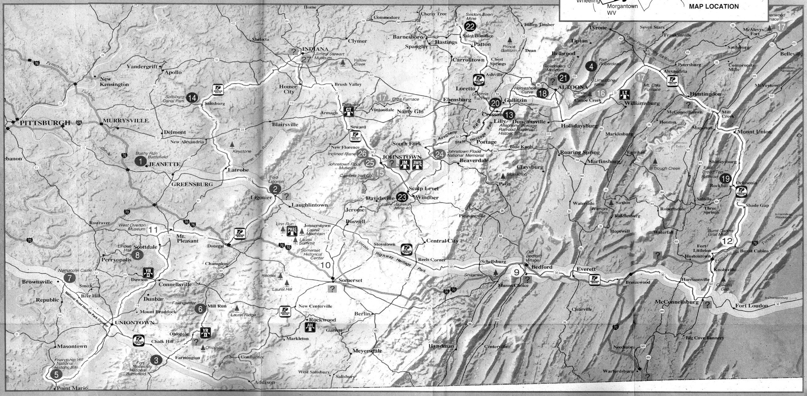
The Path of Progress was developed by the Southwestern Pennsylvania Heritage Preservation Commission and the Westsylvania Heritage Corporation (formerly the Allegheny Heritage Development Corporation). The SPHPC was created in 1987, through the U.S. Department of the Interior, to coordinate the America's Industrial Heritage Project: a regional effort to preserve, promote, and interpret the sites and stories of America's industrial heritage in southwestern Pennsylvania. The commission served as the catalyst for the project's partnership efforts, and through the conservation and commemoration of these industrial sites, the commission worked to spark economic development in the region. The Commission was based in Hollidaysburg, PA and Johnstown, PA. The nine counties are: Bedford, Blair, Cambria, Fayette, Fulton, Huntingdon, Indiana, Somerset, and Westmoreland. Through the efforts of US Representative John Murtha of Johnstown, the program received $63 million in funding from 1989-1993. A National Heritage Area is a site designated by United States and intended to encourage historic preservation of the area and an appreciation of the history and heritage of the site. As of 2017, there were 2017 National Heritage Areas in the U.S., including the Rivers of Steel area along the Monongahela River near Pittsburgh. National Heritage Areas (NHAs) are not National Park Service units or federally owned or managed land. NHAs are administered by state governments or non-profit organizations or other private corporations. The National Park Service provides an advisory role and limited technical, planning and financial assistance. NHAs are created by Congress. Each area has its own authorizing legislation and a set of unique resources and goals. Areas considered for designation must have specific elements. First, the landscape must be a nationally unique natural, cultural, historic, or scenic resource. Second, when the related sites are linked, they must tell a unique story about the U.S. Submit info or inquiry - share some facts or ask a question.
Page created:
30-Nov-1998
|
||
| copyright: © Bruce S. Cridlebaugh 1999-2008 All Rights Reserved | |||