
| |||
| Home > All By Location regional map > Ambridge > Brown Rd over East Branch Big Sewickley Creek | |||
|
|
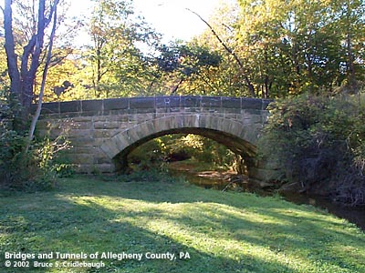
Downstream arch face, view west More detail photos OFFICIAL NAME: OTHER DESIGNATION: Brown Rd over East Branch Big Sewickley Creek SE01 ambr573-2 LOCATION: Franklin Park USGS 7.5" Topo Quad - UTM Coordinates: Ambridge - Zone 17; 0573 4495 CARRIES: Brown Rd BETWEEN: -- off Big Sewickley Creek Rd, west of State Gamelands Rd CROSSES: -- East Branch Big Sewickley Creek TYPE OF CONSTRUCTION / DESIGN: stone arch locally-quarried sandstone outer spandrel wall: rock-faced coursed ashlar upper walls and parapets: dressed coursed ashlar arch ring: dressed voussoirs in segmental arch LENGTH OF MAIN SPAN: 25 ft TOTAL LENGTH (including longest elevated ramp): 78.5 ft 19.5 ft wide, between parapets at center HEIGHT OF DECK: Lowest part of arch at abutments, 3.5 ft above creek YEAR ERECTED / ENGINEER: 1891, Charles Davis ADDITIONAL INFO: The 1985 edition of "Landmark Architecture: Pittsburgh and Allegheny County" by the Pittsburgh History and Landmarks Foundation includes this structure as the best example of its like. It is the second oldest bridge, in so far as can be positively dated by a builder's plaque, designed by Charles Davis, Allegheny County Engineer. The 1889 Woodland Rd bridge over Little Sewickley Creek in Edgeworth was also a collaboration with William Dickson as builder. Secluded on a dead end road, local residents mow a patch of a grass below the bridge giving a parklike setting. Unfortunately its seclusion has allowed vandals to add their spray-painted graffitti. A true stone arch, the voissoirs in the arch ring range in depth from 2'-8" at the abutments to 1'-10" at the keystone. A polished granite tablet is embedded at the center of the upstream parapet:
Due to the relative seclusion of this corner of Allegheny County, several older bridges can be found nearby -- illustrating the changing technology at 10 year intervals. Brown Rd spans the East Branch of Big Sewickley Creek with one of Davis' earliest stone arch bridges [1891]. A little over one-half mile north along Warrrendale & Bayne Rd, a pair of 1900 girder bridges may be found. North of these girder bridges along Warrrendale & Bayne Rd, a pair of concrete bridge span Big Sewickley Creek. The bridge on Spang Rd was built in 1910 as one of the earliest examples of what replaced Davis's stone arch bridges. A similar bridge at Markman Park Rd shows the concrete arch design still in use ten years later. FIELD CHECKED: 7-Oct-2002 INFO SOURCES: field check Submit info or inquiry - share some facts or ask a question. Introduction -- Nearby Structures Page created: 09-Jan-2003 Last modified: 09-Jan-2003 |
View Larger Map 
| |
| copyright: © Bruce S. Cridlebaugh 1999-2008 All Rights Reserved | |||