| ||||
| Home > All By Location regional map > Ambridge > I-79 Neville Island Bridge | ||||
|
|
View southwest toward Neville Island (downstream right)
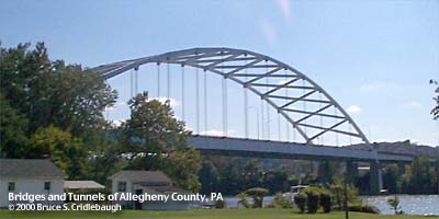
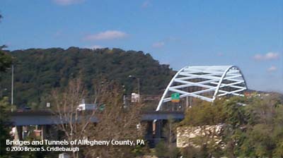
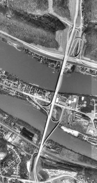
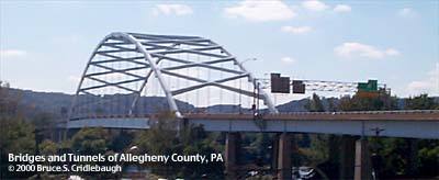
OFFICIAL NAME: OTHER DESIGNATION: I-79 Neville Island Bridge ambr573-15 LOCATION: Glenfield - Neville Twp USGS 7.5" Topo Quad - UTM Coordinates: Ambridge - Zone 17; 0573 4485 CARRIES: Raymond P. Shafer Memorial Highway [I-79]; Yellow Belt BETWEEN: -- Ohio River Blvd [PA65] (Glenfield) -- Neville Rd, Grand Av (Neville Twp) CROSSES: -- Ohio River at Mile 8.7 TYPE OF CONSTRUCTION / DESIGN: steel through tied arch; deck girder approach spans and ramps LENGTH OF MAIN SPAN: 725.0 ft TOTAL LENGTH (including longest elevated ramp): HEIGHT OF DECK: 68.0 ft YEAR ERECTED / ENGINEER: 1971-76 PennDOT ADDITIONAL INFO: (Interstate 79 Neville Island Bridge over Ohio River back channel) At 725 feet, the Neville Island Bridge carrying Interstate 79 over the Ohio River comes in second behind the West End Bridge (755 ft) for the longest single span in Allegheny County. Its span is only one foot longer than the Sewickley Bridge, about 2.5 miles downstream. The Neville Island Bridge was built at the same time as the Birmingham Bridge over the Monongahela River and, as such, is very similar in appearance. The latter's channel span is about 100 feet shorter. The crossing at Neville Island was the final link in the 180-mile north-south Interstate 79. The bridge is actually a complex of ramps and three river crossings. The main channel span over the Ohio River features the massive through arch carrying six lanes of traffic -- and bicycles on the shoulder. The ramps are box girders. The mainline of the highway crosses Neville Island about 40 feet above the ground. The back channel bridge is a pair of near twins -- each about 300 feet for the main span -- one carrying the six-lane Interstate 79 and the other carrying the single lane ramp of Exit 18. The main channel crossing is one of the few places where bicycles are allowed on an Interstate highway. Signs direct cyclists to stay on the shoulder. They are permitted only between the Glenfield (19) and Neville Island (18) exits. It was on the back channel span that the Neville Island Bridge gained most of its fame -- that is, notoriety. The main channel crossing is located in alignment with the Kilbuck Run valley through Glenfield. (Kilbuck was a Native American living in the area at the time of the first European settlers; his name is found in numerous locations, including the now-gone Kilbuck Island which became part of the north shore of the Allegheny River -- and the site of Three Rivers Stadium.) The highway fits into this natural slot in the hills along the northern shore of the Ohio River and extends across both channels of the river and Neville Island in a perfectly straight line for more than a mile -- unusual in the hills of Western Pennsylvania. The southern connection after crossing PA51 is a more torturous series of 45 mph curves with a wide median and opposing lanes at different elevation. To the south, the highway follows Moon Run into Robinson Twp. On the map, the turns are quite evident as a compromise in property rights and smooth grade. But the highway also follows an old railroad grade through this section. FIELD CHECKED: INFO SOURCES: USACE Ohio River Nav. Charts Submit info or inquiry - share some facts or ask a question. Introduction -- Nearby Structures Page created: 29-Aug-2001 Last modified: 29-Aug-2001 |
View Larger Map 
| ||
| copyright: © Bruce S. Cridlebaugh 1999-2008 All Rights Reserved | ||||