
| ||||||
| Home > All By Location regional map > Ambridge > Woodland Rd Ext over Little Sewickley Creek | ||||||
|
|
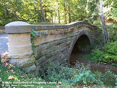
Downstream arch face More detail photos OFFICIAL NAME: OTHER DESIGNATION: Woodland Rd Ext over Little Sewickley Creek ambr568-10 LOCATION: Edgeworth USGS 7.5" Topo Quad - UTM Coordinates: Ambridge - Zone 17; 0568 4489 CARRIES: Woodland Rd Ext BETWEEN: -- Little Sewickley Creek Rd -- Woodland Rd CROSSES: -- Little Sewickley Creek TYPE OF CONSTRUCTION / DESIGN: stone arch locally-quarried sandstone outer spandrel wall: rock-faced coursed ashlar upper walls and parapets: dressed coursed ashlar arch ring: dressed voussoirs in segmental arch LENGTH OF MAIN SPAN: 29 ft TOTAL LENGTH (including longest elevated ramp): 19.5 ft wide, between parapets at center 28.5 ft wide, between parapets at portals HEIGHT OF DECK: Lowest part of arch at abutments, 6 ft above creek YEAR ERECTED / ENGINEER: 1889, Charles Davis ADDITIONAL INFO: A polished granite tablet is embedded at the center of the upstream parapet:
FIELD CHECKED: 7-Oct-2002 INFO SOURCES: field check Submit info or inquiry - share some facts or ask a question. Introduction -- Nearby Structures Page created: 03-Jan-2003 Last modified: 03-Jan-2003 |
View Larger Map 
| ||||
| copyright: © Bruce S. Cridlebaugh 1999-2008 All Rights Reserved | ||||||