
| |||
| Home > All By Location regional map > Ambridge > Merriman Rd over Big Sewickley Creek | |||
|
|
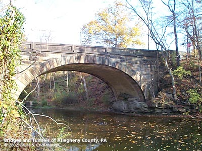
Downstream arch face More detail photos OFFICIAL NAME: OTHER DESIGNATION: Merriman Rd over Big Sewickley Creek ambr567-2 LOCATION: Bell Acres, Allegheny Co. - Economy, Butler Co. USGS 7.5" Topo Quad - UTM Coordinates: Ambridge - Zone 17; 0567 4493 CARRIES: Merriman Rd BETWEEN: -- Big Sewickley Creek Rd -- Semack Ct CROSSES: -- Big Sewickley Creek TYPE OF CONSTRUCTION / DESIGN: filled concrete arch with stone facing locally-quarried sandstone outer spandrel wall: rock-faced coursed ashlar upper walls and parapets: dressed coursed ashlar arch ring: dressed voussoirs in three-centered arch LENGTH OF MAIN SPAN: 47 ft TOTAL LENGTH (including longest elevated ramp): 96 ft 19.5 ft wide, between parapets at center HEIGHT OF DECK: YEAR ERECTED / ENGINEER: 1916, Allegheny and Beaver counties ADDITIONAL INFO: This bridge shares the design of its parapet stonework with the Beaver Rd bridge over the same creek about one-half mile downstream. The Beaver Rd bridge was a 1919 rebuilding of one of the counties' earliest bridges. The builder plate on that bridge reports the bridge as a collaboration between Allegheny and Beaver counties. Since the builder plate has been stolen from the Merriman bridge, it must be presumed that this bridge was a similar collaboration. The Merriman bridge, having been built in 1916, was constructed under the term of Allegheny County Engineer, James G. Chalfant. It has some similarity to others designed by his office, but differs enough to indicate the Beaver counties authorities may have had some influence on the design. Chalfant's bridges of this time and type feature stepped voissoirs as shown at the 1915 Burchfield bridge; the Merriman bridge does not. Only nine of these county bridges -- filled concrete arch with stone facing -- are known to exist. Most of the bridges built by the county at this time and afterward were built of concrete only. Their design was intended to mimic the form of the older stone arches, but without the expense -- or impressive aethetics -- of the stonework. The Merriman bridge features a three-centered arch. A smaller radius curve defines each end of the arch near the abutments, while a larger radius curve forms the center of the span. The parapet wall on this bridge are more massive than others of its type: two feet wide and over three feet high at the center with endcaps over two and a half feet wide. The top of the parapets share the rounded dressed ashlar of other Allegheny County stone bridges, but the vertical faces have rectangular, recessed coffers. The endcaps also have diagonal painted stripes to warn of the narrow entry onto the bridge. Merriman Rd rises from a floodplain on the northwestern side of the creek to meet Big Sewickley Creek Rd. In the 96 feet across the structure, the road rises approximately two feet. The 1876 Atlas of Allegheny County shows a road along the hillside and following the right descending bank of Big Sewickley Creek to Beaver Rd in Ambridge. Only a stub of the road seems to survive near the Beaver Rd bridge, and Valley Rd no longer connects to Merriman Rd. Warner's 1889 History of Allegheny County notes Fredrick Merriman, a soldier with General "Mad" Anthony Wayne's legion, as the earliest settler in Sewickley township in 1808. The township was erected in 1854 from the land to the west of line between Alexander's and Nicholson's districts in the Depreciations Lands. The 1876 Atlas of Allegheny County shows various descendents of Merriman in the town and township of Sewickley Township and to the east in Aleppo. The 1904 Memoirs of Allegheny County notes Samuel Merriman as another of the first settlers in the area and states the family burial grounds in Aleppo as one of the oldest in the county. None of the family, however, are shown in the immediate vicinty of Merriman Rd.; the nearest was W. Merriman near the intersection of Hitzel Hill and Willow Ridge roads. Other descendants are noted in nearby Beaver county. FIELD CHECKED: 3-Nov-2002 INFO SOURCES: field check; Warner, "History of Allegheny County," 1889; Hopkins, "Atlas of Allegheny County," 1876; Northwestern Historical Association, "Memoirs of Allegheny County," 1904 Submit info or inquiry - share some facts or ask a question. Introduction -- Nearby Structures Page created: 14-Feb-2003 Last modified: 14-Feb-2003 |
View Larger Map 
| |
| copyright: © Bruce S. Cridlebaugh 1999-2008 All Rights Reserved | |||